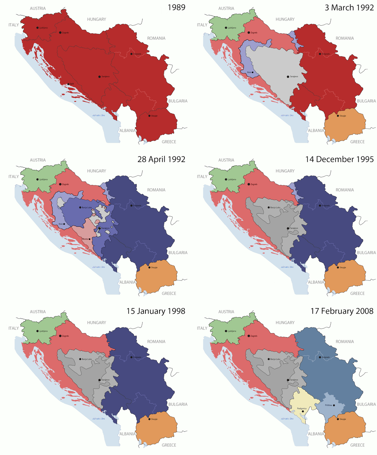
Bestand:Breakup of Yugoslavia.gif

Afbeelding in hogere resolutie (1.545 × 1.242 pixels, bestandsgrootte: 187 kB, MIME-type: image/gif, herhalend, 14 frames, 44 s)
Let op: vanwege technische beperkingen, kunnen miniaturen van GIF-afbeeldingen met een hoge resolutie niet geanimeerd worden weergegeven.
Dit bestand is afkomstig van Wikimedia Commons en kan ook in andere projecten gebruikt worden. De bestandsbeschrijvingspagina wordt hieronder weergegeven.

|
This image could be re-created using vector graphics as an SVG file. This has several advantages; see Commons:Media for cleanup for more information. If an SVG form of this image is available, please upload it and afterwards replace this template with
{{vector version available|new image name}}.
It is recommended to name the SVG file "Breakup of Yugoslavia.svg" - then the template Vector version available (or Vva) does not need the new image name parameter. |
Beschrijving
Key:
| Yugoslavia (1943–1992) | |||
| Croatia (1991–present) | |||
| Herzeg-Bosnia (1992–1994) | |||
| UNTAES (1996–1998) | |||
| Federal Republic of Yugoslavia / Serbia and Montenegro (1992–2006) | |||
| Republika Srpska (1992–present) | |||
| Serbian Krajina (1991–1995/96) | |||
| Republic of Bosnia and Herzegovina (1992–1995) | |||
| Bosnia and Herzegovina (1998–present) | |||
| Western Bosnia (1993–1995) | |||
| Serbia (2006–present) | |||
| Kosovo (under UNMIK control 1999–present; declaration of independence 2008) | |||
| Montenegro (2006–present) | |||
| Macedonia (1991–present) | |||
| Slovenia (1991–present) |
| BeschrijvingBreakup of Yugoslavia.gif |
This is an animated GIF that shows the stages of the breakup of the SFR Yugoslavia in the 90's and 2000's. The map based off Morwen's map of the divisions of the SFRY, Which is licensed by the GFDL. The source for the dates of independence is the CIA World Factbook. These maps
Changelog for version 4:
Changelog for version 5:
|
| Datum | 24 July 2006 (orginal upload date) |
| Bron | Made by Hoshie; see above for more details on sources. |
| Auteur | Hoshie |
| Andere versies |
|
Licentie

|
Toestemming wordt verleend voor het kopiëren, verspreiden en/of wijzigen van dit document onder de voorwaarden van de GNU-licentie voor vrije documentatie, versie 1.2 of enige latere versie als gepubliceerd door de Free Software Foundation; zonder Invariant Sections, zonder Front-Cover Texts, en zonder Back-Cover Texts. Een kopie van de licentie is opgenomen in de sectie GNU-licentie voor vrije documentatie.http://www.gnu.org/copyleft/fdl.htmlGFDLGNU Free Documentation Licensetruetrue |
| Dit bestand is gelicenseerd onder de Creative Commons-licentie Naamsvermelding-Gelijk delen 3.0 Unported | ||
| ||
| Deze licentietag is toegevoegd aan dit bestand in verband met de GFDL licentie-update.http://creativecommons.org/licenses/by-sa/3.0/CC BY-SA 3.0Creative Commons Attribution-Share Alike 3.0truetrue |
Bijschriften
Items getoond in dit bestand
beeldt af
Waarde zonder Wikidata-item
image/gif
05ca2aefea8406b809968643552d5095c847a42f
191.625 byte
44 seconde
1.242 pixel
1.545 pixel
Bestandsgeschiedenis
Klik op een datum/tijd om het bestand te zien zoals het destijds was.
| Datum/tijd | Miniatuur | Afmetingen | Gebruiker | Opmerking | |
|---|---|---|---|---|---|
| huidige versie | 17 jul 2016 09:40 |  | 1.545 × 1.242 (187 kB) | מפתח-רשימה | Reverted to version as of 17:22, 21 August 2015 (UTC) |
Bestandsgebruik
Dit bestand wordt op de volgende 3 pagina's gebruikt:
Metadata
Dit bestand bevat aanvullende gegevens, die waarschijnlijk door een fotocamera, scanner of fotobewerkingsprogramma toegevoegd zijn.
Als het bestand is aangepast, komen sommige details mogelijk niet overeen met het gewijzigde bestand.
| Gebruikte software | Adobe Photoshop CS5.1 Windows |
|---|


