Bestand:Trinidad and Tobago OnEarth WMS.png
Naar navigatie springen
Naar zoeken springen


Grootte van deze voorvertoning: 644 × 600 pixels. Andere resoluties: 258 × 240 pixels | 515 × 480 pixels | 825 × 768 pixels | 1.099 × 1.024 pixels | 2.058 × 1.917 pixels.
Afbeelding in hogere resolutie (2.058 × 1.917 pixels, bestandsgrootte: 4,03 MB, MIME-type: image/png)
Beschrijving
| Beschrijving |
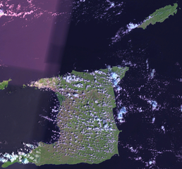
English: Satellite image of Trinidad and Tobago. |
| Datum | 1 mei 2006 (uploaddatum) |
| Bron | Satellite imagery taken from NASA World Wind software (by screenshot). OnEarth WMS global mosaic pseudocolor layer. |
| Auteur | NASA |
Licentie
| Deze afbeelding bevindt zich in het publiek domein omdat het een screenshot is van NASA’s software World Wind die gebruik maakt van een publiek domein-laag, zoals Blue Marble, MODIS, Landsat, SRTM, USGS of GLOBE.
|
 |
Bestandsgeschiedenis
Klik op een datum/tijd om het bestand te zien zoals het destijds was.
| Datum/tijd | Miniatuur | Afmetingen | Gebruiker | Opmerking | |
|---|---|---|---|---|---|
| huidige versie | 1 mei 2006 18:36 | | 2.058 × 1.917 (4,03 MB) | Hautala | {{PD-WorldWind}} Satellite image of Trinidad and Tobago. Screenshot from NASA World Wind, OnEarth WMS layer. Category:Satellite images of countries |
Bestandsgebruik
Dit bestand wordt op de volgende pagina gebruikt: