Bestand:Canada population per senator map.svg
Naar navigatie springen
Naar zoeken springen


Afmetingen van deze voorvertoning van het type PNG van dit SVG-bestand: 619 × 600 pixels Andere resoluties: 248 × 240 pixels | 496 × 480 pixels | 793 × 768 pixels | 1.057 × 1.024 pixels | 1.304 × 1.263 pixels.
Afbeelding in hogere resolutie (SVG-bestand, nominaal 1.304 × 1.263 pixels, bestandsgrootte: 113 kB)
Beschrijving
| Beschrijving |
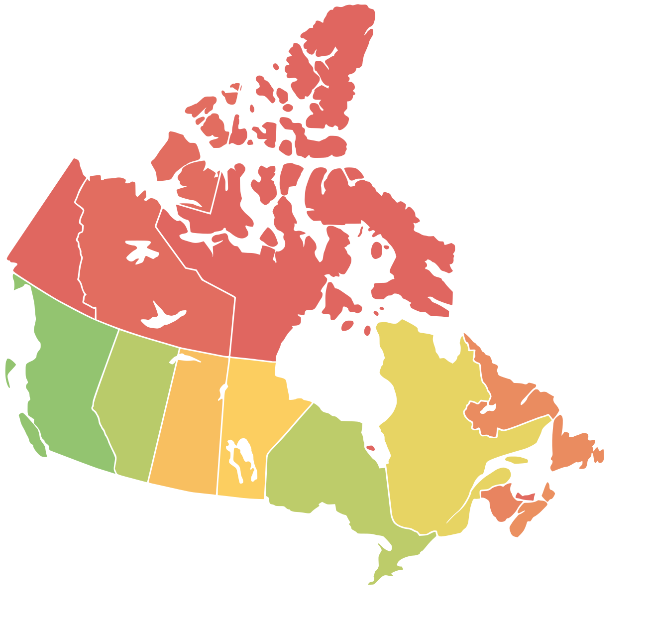
English: A map of Canda with a colored representation of the population per senator in each region. Red=Least Population (=> overrepresented), Yellow=Average, Green=Most Population (=> underrepresented) |
| Datum | |
| Bron | Based on Numbers from Wikipedia and a blank map of Canada (File:Canada_blank_map.svg) |
| Auteur | Moritz Ahrens, Lokal_Profil, Paul Robinson |
Licentie
Dit bestand is gelicenseerd onder de Creative Commons Naamsvermelding-GelijkDelen 4.0 Internationaal licentie.
- De gebruiker mag:
- Delen – het werk kopiëren, verspreiden en doorgeven
- Remixen – afgeleide werken maken
- Onder de volgende voorwaarden:
- naamsvermelding – U moet op een gepaste manier aan naamsvermelding doen, een link naar de licentie geven, en aangeven of er wijzigingen in het werk zijn aangebracht. U mag dit op elke redelijke manier doen, maar niet zodanig dat de indruk wordt gewekt dat de licentiegever instemt met uw werk of uw gebruik van zijn werk.
- Gelijk delen – Als u het materiaal remixt, transformeert of erop voortbouwt, moet u uw bijdragen verspreiden onder dezelfde licentie als die van het origineel, of een licentie die daarmee verenigbaar is.
Bestandsgeschiedenis
Klik op een datum/tijd om het bestand te zien zoals het destijds was.
| Datum/tijd | Miniatuur | Afmetingen | Gebruiker | Opmerking | |
|---|---|---|---|---|---|
| huidige versie | 20 mei 2019 14:01 | | 1.304 × 1.263 (113 kB) | Moritz157 | {{Information |description ={{en|1=A map of Canda with a colored representation of the population per senator in each region. Red=Least Population (=> overrepresented), Yellow=Average, Green=Most Population (=> underrepresented)}} |date =20.05.2019 |source =Based on Numbers from Wikipedia and a blank map of Canada (https://commons.wikimedia.org/wiki/File:Canada_blank_map.svg) |author =Moritz Ahrens, Lokal_Profil, Paul Robinson }} |
Bestandsgebruik
Dit bestand wordt op de volgende pagina gebruikt: