Bestand:Eu cartogram.png
Naar navigatie springen
Naar zoeken springen
Geen hogere resolutie beschikbaar.
Eu_cartogram.png (490 × 436 pixels, bestandsgrootte: 10 kB, MIME-type: image/png)
Beschrijving
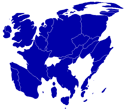
| Beschrijving |
English: A cartogram depicting population distribution within the European Union at the member state level. Note how roughly half of all citizens within the EU live within the 4 largest member states: Germany, France, United Kingdom, and Italy. |
| Datum | |
| Bron | Self-made, referenced from a similiar cartogram at worldmapper.net |
| Auteur | Geoilex |
Licentie
| Ik, de auteursrechthebbende van dit werk, geef dit werk vrij in het publieke domein. Dit is wereldwijd van toepassing. In sommige landen is dit wettelijk niet mogelijk; in die gevallen geldt: Ik sta iedereen toe dit werk voor eender welk doel te gebruiken, zonder enige voorwaarden, tenzij zulke voorwaarden door de wet worden voorgeschreven. |
Bestandsgeschiedenis
Klik op een datum/tijd om het bestand te zien zoals het destijds was.
| Datum/tijd | Miniatuur | Afmetingen | Gebruiker | Opmerking | |
|---|---|---|---|---|---|
| huidige versie | 27 mrt 2008 11:54 | | 490 × 436 (10 kB) | Geoilex | {{Information |Description= A cartogram depicting population distribution within the European Union at the member state level. Note how roughly half of all citizens within the EU live within the 4 largest member states: Germany, France, United Kingdom, an |
Bestandsgebruik
Dit bestand wordt op de volgende pagina gebruikt: