Bestand:Lake Winnipeg map.png
Naar navigatie springen
Naar zoeken springen


Grootte van deze voorvertoning: 575 × 600 pixels. Andere resoluties: 230 × 240 pixels | 460 × 480 pixels | 1.000 × 1.043 pixels.
Afbeelding in hogere resolutie (1.000 × 1.043 pixels, bestandsgrootte: 92 kB, MIME-type: image/png)
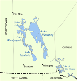
| Beschrijving | Map showing the location of Lake Winnipeg, Lake Manitoba, and Lake Winnipegosis in Manitoba, Canada. | ||
| Datum | |||
| Bron | Eigen werk | ||
| Auteur | NormanEinstein | ||
| Toestemming (Hergebruik van dit bestand) |
Ik, de auteursrechthebbende van dit werk, maak het hierbij onder de volgende licenties beschikbaar: Dit bestand is gelicenseerd onder de Creative Commons-licentie Naamsvermelding-Gelijk delen 3.0 Unported
U mag zelf één van de licenties kiezen. |
||
| Andere versies |
Afgeleide werken van dit bestand: |

Bestandsgeschiedenis
Klik op een datum/tijd om het bestand te zien zoals het destijds was.
| Datum/tijd | Miniatuur | Afmetingen | Gebruiker | Opmerking | |
|---|---|---|---|---|---|
| huidige versie | 31 mei 2006 17:41 | | 1.000 × 1.043 (92 kB) | NormanEinstein | Map showing the location of Lake Winnipeg, Lake Manitoba, and Lake Winnipegosis in Manitoba, Canada. Created by NormanEinstein, May 31, 2006. {{GFDL-self}} Category:Maps of Manitoba |
Bestandsgebruik
Dit bestand wordt op de volgende pagina gebruikt: