Bestand:Map plate tectonics world.gif
Naar navigatie springen
Naar zoeken springen

Grootte van deze voorvertoning: 800 × 503 pixels. Andere resoluties: 320 × 201 pixels | 640 × 402 pixels | 859 × 540 pixels.
Afbeelding in hogere resolutie (859 × 540 pixels, bestandsgrootte: 26 kB, MIME-type: image/gif)
Beschrijving
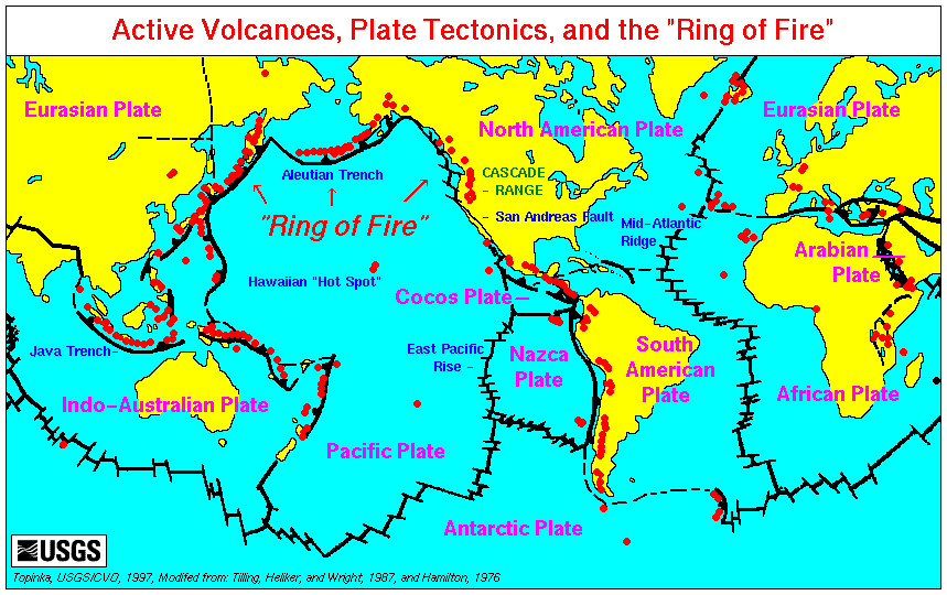
English: World map showing plate boundaries and active volcanoes.
Source: http://vulcan.wr.usgs.gov/Glossary/PlateTectonics/Maps/map_plate_tectonics_world.html
Licentie
Deze afbeelding bevindt zich in het publiek domein omdat het materiaal bevat dat oorspronkelijk afkomstig is van de United States Geological Survey, een agentschap van de United States Department of the Interior. Voor meer informatie, zie het officiële USGS-auteursrechtenbeleid
|
Bestandsgeschiedenis
Klik op een datum/tijd om het bestand te zien zoals het destijds was.
| Datum/tijd | Miniatuur | Afmetingen | Gebruiker | Opmerking | |
|---|---|---|---|---|---|
| huidige versie | 10 sep 2007 02:43 | | 859 × 540 (26 kB) | Avenue | World map showing plate boundaries and active volcanoes. Source: http://vulcan.wr.usgs.gov/Glossary/PlateTectonics/Maps/map_plate_tectonics_world.html |
Bestandsgebruik
Dit bestand wordt op de volgende pagina gebruikt: