Bestand:Pecosmap.png
Naar navigatie springen
Naar zoeken springen


Grootte van deze voorvertoning: 583 × 599 pixels. Andere resoluties: 233 × 240 pixels | 467 × 480 pixels | 584 × 600 pixels | 864 × 888 pixels.
Afbeelding in hogere resolutie (864 × 888 pixels, bestandsgrootte: 860 kB, MIME-type: image/png)
Beschrijving
| Beschrijving |
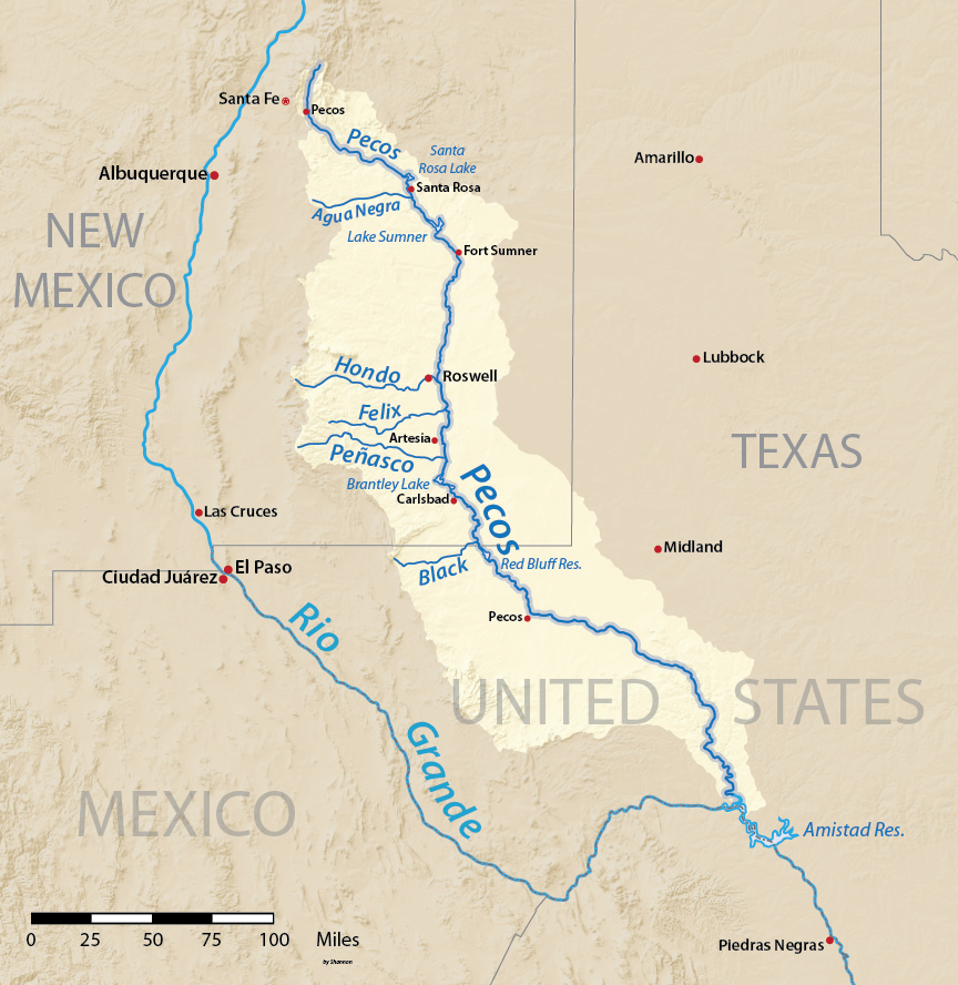
English: Map of the watershed of Pecos River, a tributary of the Rio Grande, in New Mexico and Texas, USA. Made using USGS National Map data. |
| Datum | |
| Bron | Eigen werk |
| Auteur | Shannon1 |
Licentie
Ik, de auteursrechthebbende van dit werk, maak het hierbij onder de volgende licenties beschikbaar:

|
Toestemming wordt verleend voor het kopiëren, verspreiden en/of wijzigen van dit document onder de voorwaarden van de GNU-licentie voor vrije documentatie, versie 1.2 of enige latere versie als gepubliceerd door de Free Software Foundation; zonder Invariant Sections, zonder Front-Cover Texts, en zonder Back-Cover Texts. Een kopie van de licentie is opgenomen in de sectie GNU-licentie voor vrije documentatie. |
Dit bestand valt onder de licenties Creative Commons Naamsvermelding-GelijkDelen 4.0 Internationaal, 3.0 Unported, 2.5 Generic, 2.0 Generic en 1.0 Generic.
- De gebruiker mag:
- Delen – het werk kopiëren, verspreiden en doorgeven
- Remixen – afgeleide werken maken
- Onder de volgende voorwaarden:
- naamsvermelding – U moet op een gepaste manier aan naamsvermelding doen, een link naar de licentie geven, en aangeven of er wijzigingen in het werk zijn aangebracht. U mag dit op elke redelijke manier doen, maar niet zodanig dat de indruk wordt gewekt dat de licentiegever instemt met uw werk of uw gebruik van zijn werk.
- Gelijk delen – Als u het materiaal remixt, transformeert of erop voortbouwt, moet u uw bijdragen verspreiden onder dezelfde licentie als die van het origineel, of een licentie die daarmee verenigbaar is.
U mag zelf één van de licenties kiezen.
Bestandsgeschiedenis
Klik op een datum/tijd om het bestand te zien zoals het destijds was.
| Datum/tijd | Miniatuur | Afmetingen | Gebruiker | Opmerking | |
|---|---|---|---|---|---|
| huidige versie | 31 mrt 2016 04:37 | | 864 × 888 (860 kB) | Shannon1 | {{Information |Description ={{en|1=Map of the watershed of Pecos River, a tributary of the Rio Grande, in New Mexico and Texas, USA. Made using USGS National Map data.}} |Source =Own work |Author =Shannon1 |Date... |
Bestandsgebruik
Dit bestand wordt op de volgende pagina gebruikt: