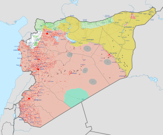
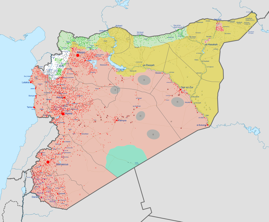
Bestand:Syrian Civil War map.svg

Afbeelding in hogere resolutie (SVG-bestand, nominaal 922 × 762 pixels, bestandsgrootte: 3,47 MB)

Beschrijving
| Beschrijving |
English: Map of the Syrian civil war. Español: Mapa de la Guerra civil siria
Information to readers: Click on the image to make marks and icons visible, which are otherwise too small. To zoom into the image after you opened it, hold ctrl and scroll in/out with your mouse. To view the image in full quality, open it in Media Viewer, download the original file and open it with Inkscape (free drawing program). If you want to see the history of the Syrian civil war before August 2016, look at Syrian civil war.png. Information to editors: This file is completely based on the Template:Syrian Civil War detailed map. If you want to change something here, you first need to make a properly sourced edit at the Templates' Module. The program that you need to edit the map (and any other Scalable Vector Graphics-file (SVG)) is called Inkscape, which is a free accessible program. To be able to add marks and icons at the correct place, it is recommend to make a screenshot (alt gr + print). This screenshot you insert temporarily at the file, put it in the right size under the marks and then look at the streets and the borders, if it's at the right place. If you did this, you only need to look, where the Template shows a mark which isn't already at the map. Good luck and thanks for helping to improve the map! |
||||
| Map legend |
Bahasa Indonesia: Dikuasai oleh Angkatan Bersenjata Suriah
Dikuasai oleh Angkatan Kurdi
Dikuasai oleh Negara Islam Irak dan Syam
Wilayah dipertentangkan
Dikuasai oleh Angkatan Oposisi Bosanski: Pod kontrolom Vladinih snaga
Pod kontrolom Kurda
Pod kontrolom ISIL-a
Linija između suprotstavljenih snaga
Pod kontrolom Opozicije i pobunjenika Català: Controlat pel govern
Controlat pels kurds
Controlat per l'Estat Islàmic
Controlat per forces rebels
Controlat per Tahrir al-Xam
Zones disputades Čeština: Pod kontrolou syrské vlády
Pod kontrolou syrské opozice
Pod kontrolou syrských Kurdů
Pod kontrolou Islámského státu
Pod kontrolou Tahrír al-Šám
Sporná hranice mezi válčícími stranami Dansk: Kontrolleret af pro-Assad-styrker
Kontrolleret af syriske kurdere
Kontrolleret af Islamisk Stat (Daesh / IS / ISIL)
Omstridt område
Kontrolleret af den Syriske Nationale Koalition (den syriske opposition)
Kontrolleret af Al-Nusra-Fronten Deutsch:
keine Kontrolle
English:
Español:
En los respectivos colores: Euskara:
Hegoaldeko Operazio Aretoko matxinoen kontrolpean
Inork ez kontrolatua
Français : Fronts
Hrvatski: Pod kontrolom Assadovih snaga
Pod kontolom Kurda
Pod kontrolom ISIL-a
Linija između suprotstavljenih snaga
Pod kontrolom protuvladinih snaga Italiano:
Linea di frontiera contesa tra le forze
Magyar: A szíriai hadsereg ellenőrzése alatt
A szíriai kurdok ellenőrzése alatt
Az Iszlám Állam ellenőrzése alatt
A szíriai ellenzéki erők koalíciójának ellenőrzése alatt
Az Al-Nuszra Front ellenőrzése alatt
Vitatott ellenőrzésű terület Nederlands: In handen van de Syrische overheid
In handen van Koerdische troepen (Rojava)
In handen van de Islamitische Staat (in Irak en de Levant) (ISIS)
Betwist gebied
Gecontroleerd door anti-Assad strijders Polski:
Português: Zonas controladas por forças pro-Assad
Zonas controladas por forças curdas
Zonas controladas pelo Estado Islâmico
Zonas em disputa
Zonas controladas por outras forças anti-Assad Română: Zone controlate de forțele pro-Assad
Zone controlate de forțele kurde
Zone controlate de forțele Statului Islamic
Zone disputate
Zone controlate de forțele anti-Assad Shqip: E kontrolluar nga forcat e Assadit
E kontrolluar nga forcat Kurde
E knontrolluar nga Shteti Islamik i Irakut dhe Levantit
E kontrolluar nga rebelet anti-Assad Slovenščina: Pod nadzorom sirijske vlade
Pod nadzorom sirijske opozicije
Pod nadzorom sirijskih Kurdov
Pod nadzorom Islamske države
Pod nadzorom al-Nusre
Sporno območje med več stranmi Tiếng Việt: Kiểm soát bởi lực lượng thân Assad
Kiểm soát bởi lực lượng người Kurd
Kiểm soát bởi lực lượng chống Assad Türkçe:
Ελληνικά:
κανένας έλεγχος
Η διαφιλονικούμενη γραμμή του μετώπου ανάμεσα σε αντίπαλες δυνάμεις Беларуская:
Спрэчная тэрыторыя паміж ваюючымі бакамі
Беларуская (тарашкевіца): Пад кантролем урада Асада
Пад кантролем курдскіх сілаў
Пад кантролем Ісламскай Дзяржавы (ІДІЛ)
Спрэчныя тэрыторыі
Пад кантролем апазыцыі Български: Под контрол на правителствените сили
Под контрол на кюрдските милиции
Под контрол на ИДИЛ
Оспорвани земи
Под контрол на бунтовниците Русский:
Спорная территория между воюющими сторонами
Српски (ћирилица): Под контролом Асадових снага
Под контролом Курда
Под контролом Исламске Државе
Линија између супрострављених снага
Под контролом побуњеничких снага Українська: Під контролем уряду Асада
Під контролем курдських сил
Під контролем Ісламської Держави (ІДІЛ)
Спірні території
Під контролем опозиції ქართული: კონტროლირდება სირიის მთავრობის მიერ
კონტროლირდება სირიელი ქურთების მიერ
კონტროლირდება დაეშ-ის მიერ
საკამათო ტერიტორია
კონტროლირდება სირიის ოპოზიციის მიერ Հայերեն : Վերահսկվում է Սիրիական կառավարական ուժերի կողմից
Վերահսկվում է քրդերի կողմից
Վերահսկվում է ընդդիմադիր ուժերի կողմից
Վերահսկվում է "ան-Նուսրա" խմբավորման կողմից
Վերահսկվում է "Իրաքի և Լևանտի իսլամական պետության" կողմից
Հակամարտող կոմղերի միջև վիճելի տարածքներ संस्कृतम् : असदसमर्थक सेनानाम् नियन्त्रणे क्षेत्राः
कुर्द सेनानाम् नियन्त्रणे क्षेत्राः
ISIS सेनानाम् नियन्त्रणे क्षेत्राः
सेनानाम् मध्ये विवदित क्षेत्राः
असदविरोधी सेनानाम् नियन्त्रणे क्षेत्राः 한국어:
日本語:
無制御下
中文:
無控制者
閩南語 / Bân-lâm-gí: Kok sè-le̍k saⁿ-cheⁿ ê chiân-sòaⁿ
עברית : בשליטת כוחות נאמני אסד
בשליטת כוחות כורדים
בשליטת כוחות דאע"ש
איזור במחלוקת בין הכוחות
בשליטת כוחות מתנגדי אסד العربية :
تۆرکجه : سوریه حکومتی سیلاحلی گوجلری
عراق و شام ایسلام دؤلتی
سوریه موخالیفلری
النوصره جبههسی
سوریه دموکراتیک گوجلری
ساواشما گئدن یادا ایختیلافلی بؤلگهلر
فارسی : در دست ارتش سوریه
در دست نیروهای کرد
در دست داعش
مناطق درگیری
در دست مخالفان اسد
در دست تحریر الشام کوردی: سوپای ڕژێم
هێزه كوردیهكان
دهوڵهتی ئیسلامی له عیڕاق و شام
ئهو ناوچانهی چارهنوسیان یهكلا نهبۆتهوه
هێزهكانی ئۆپۆزسیۆن |
||||
| Datum | |||||
| Bron |
Eigen werk, derived from the Template:Syrian Civil War detailed map.
|
||||
| Maker | |||||
| Georeferencing | If inappropriate please set warp_status = skip to hide. | ||||
| Andere versies |
|


.svg)
.svg)


.svg)


.svg)

.svg)


_Territory_Change_2014-2016.gif)

_(within_Northern_Syria).svg)


.png)
.svg)


_map.png)
.svg)


.svg)


Licentie
- De gebruiker mag:
- Delen – het werk kopiëren, verspreiden en doorgeven
- Remixen – afgeleide werken maken
- Onder de volgende voorwaarden:
- naamsvermelding – U moet op een gepaste manier aan naamsvermelding doen, een link naar de licentie geven, en aangeven of er wijzigingen in het werk zijn aangebracht. U mag dit op elke redelijke manier doen, maar niet zodanig dat de indruk wordt gewekt dat de licentiegever instemt met uw werk of uw gebruik van zijn werk.
- Gelijk delen – Als u het materiaal remixt, transformeert of erop voortbouwt, moet u uw bijdragen verspreiden onder dezelfde licentie als die van het origineel, of een licentie die daarmee verenigbaar is.
Bestandsgeschiedenis
Klik op een datum/tijd om het bestand te zien zoals het destijds was.
| Datum/tijd | Miniatuur | Afmetingen | Gebruiker | Opmerking | |
|---|---|---|---|---|---|
| huidige versie | 28 jan 2025 23:39 | | 922 × 762 (3,47 MB) | Ecrusized | Update |
Bestandsgebruik
Dit bestand wordt op de volgende pagina gebruikt: